
Auckland Council’s Flood Viewer helps locals understand flooding hazards in their neighbourhood — and take practical steps to prepare
Papakura has been living with floods for generations. But knowing your street’s flood story doesn’t require digging through council archives or expensive reports anymore. Auckland Council’s Flood Viewer puts flood risk information at your fingertips in about three clicks.
“Council has had flooding information available for the whole region for over a decade,” explains Nancy Baines, Principal – Flood Risk at Auckland Council. “But publicly available doesn’t mean it’s easy to use or understand. That’s why we created the Flood Viewer — a one-stop shop to find out your risk, understand what it means, and learn the next steps.”
After ten minutes with the Flood Viewer, I hope locals will feel confident understanding their flood risk and knowing steps they can take
nancy Baines, Principal – Flood Risk at Auckland Council
What the Flood Viewer Shows
The Flood Viewer is a free, searchable online map that turns complex flood modelling data into something easier to understand. It was also the first time Council could provide flood information on mobile phones, not just desktop computers — a significant change that made the information accessible to more people.
After the devastating January 2023 floods, there was much greater demand for clear, easy-to-understand flood risk information. The Flood Viewer was designed to meet that need.
But Baines clarifies what the tool does and doesn’t show. “People are often surprised that the Flood Viewer shows floodplains where they may not have seen water before,” she says. “We use predicted data in a consistent way to show what could happen [emphasis added].”
The maps show a “1% annual exceedance probability event” — in plain English, that means in any given year, there’s a 1% chance of experiencing that flooding. Some areas within the floodplain will flood more frequently than this. “If you’ve only lived in your house for a few years or even ten years, you may not have seen that rainfall before,” Baines explains.
Importantly, the floodplains also include climate change projections and future development. “Flood plains are used for development and so we look at the entire life of a building, not just the next few years,” she says.
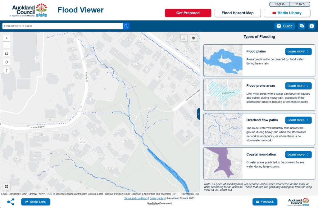
Understanding the Four Flood Layers
The Flood Viewer displays four different types of flood hazards. Here’s what each one means:
Flood Plains: These show areas predicted to be covered by floodwater during heavy rain. They represent larger, less frequent rainfall events that include climate change impacts.
Flood-Prone Areas: Low points where water can pool, especially when stormwater systems become overwhelmed or blocked.
Overland Flow Paths: “These are the routes that water takes as it travels through the catchment from wherever the rain falls to the bottom,” Baines explains. “Imagine dropping a ball at the top — the path it takes as it rolls downhill, that’s the overland flow path. These can activate in short, sharp bursts of intense rainfall.”
What’s interesting about overland flow paths is that residents can commonly do something about them if they have one on their property. “You can make small changes — like not blocking your flow path when placing your shed or planter boxes, and having fences which let the water through” Baines notes. However, she cautions that you should investigate if you need consent for large changes.
Coastal Inundation: For coastal areas, this layer shows areas predicted to be covered by sea water during large storms combined with high tides.
“The biggest myth that we have to bust is that it’s safe to go into flood waters. It is not. Do not ever enter flood waters.”
nancy Baines, Principal – Flood Risk at Auckland Council
It’s Not Just for Homeowners
One of the biggest misconceptions about the Flood Viewer is that it’s only useful for people buying or selling property. Baines wants everyone in Auckland to know they can benefit from it.
The tool can help renters ask better questions at viewings, understand what to document or photograph, and know what drainage or storage questions to raise with landlords or body corporates. Knowing your flood risk helps with everyday decisions — like where to park during heavy rain or what to store on lower shelves.
“After ten minutes with the Flood Viewer, I hope locals will feel confident understanding their flood risk and knowing steps they can take,” says Baines. That empowerment includes quick actions like parking uphill during heavy rain, or longer-term decisions like adjusting landscaping to keep water away from doorways.
Knowledge Is Power — And Safety
Baines emphasizes that knowing your risk is far better than being caught unprepared. “The worst outcome is not knowing we’re at risk, and then a flood comes and we’re completely taken aback,” she says. “We want people to know ahead of time. Knowledge is power.”
But she also wants to bust one critical myth: “The biggest myth that we have to bust is that it’s safe to go into flood waters. It is not. Do not ever enter flood waters.”
Her message for Papakura residents is clear: “If you remember one thing about flood risk in Papakura, it’s do not enter flood water — either on foot or in a car. “
Taking Action
The Flood Viewer’s “Get Prepared” page offers many free, low-commitment steps residents can take. Baines encourages everyone to explore these practical actions.
The tool is also designed with accessibility in mind. The Flood Viewer has a bilingual intro in English and te reo Māori, with guides available in eight languages and videos in four languages, including New Zealand Sign Language. If you have any accessibility issues, contact Council through the feedback button or by calling directly.
“There are lots of easy, free steps on the Get Prepared page that don’t require a big-time commitment,” says Baines. “I’d really encourage people to have a look.”
Access the Auckland Flood Viewer: Visit www.aucklandcouncil.govt.nz/floodviewer and search your address to see flood layers for your property. For questions or support, use the feedback button in the Flood Viewer or contact Auckland Council.

0 Comments