
Papakura sits at the confluence of some of New Zealand’s most challenging flood risks. While Auckland’s wettest day on record—27 January 2023—made headlines across the region, it was communities like Papakura that bore the brunt of what happens when climate change, rapid urban growth, and unique geography collide. Unlike many flood-prone areas that face a single dominant risk, Papakura confronts multiple compounding pressures: increasingly intense rainfall, tide-locked drainage systems, explosive population growth, and infrastructure struggling to keep pace.
This convergence makes Papakura’s flood challenge both urgent and instructive. As New Zealand grapples with climate adaptation, Papakura’s experience offers insights into how communities can respond when traditional flood management approaches meet twenty-first-century realities. The town’s collaborative response—bringing together council planning, mana whenua knowledge, community organising, and individual preparedness—provides a framework that other communities facing similar compound risks might adapt.
This analysis examines the evidence behind Papakura’s unique flood vulnerability, documents current responses from council and community levels, and identifies practical next steps for residents and decision-makers. The article is intended for Papakura area residents seeking to understand their flood risk, local officials planning resilience strategies, and other New Zealand communities facing similar challenges. It balances technical projections with accessible explanations, providing both the evidence base for policy decisions and practical guidance for household preparation.
The following sections trace how multiple risks are intensifying simultaneously in Papakura, what responses are already underway, and how residents can contribute to community-wide flood resilience. Rather than offering simple solutions to complex problems, this analysis maps the interconnected nature of Papakura’s flood challenge and the correspondingly multifaceted approaches needed to address it.
What we mean by “Papakura” in this guide Stats and maps use the Papakura Local Board area (Papakura centre plus Takanini, Ōpāheke, Hingaia, Pahurehure, Red Hill and urban Drury). We write “Papakura area” so everyone in these neighbourhoods recognises themselves.
Big 5 Numbers: Papakura at a Glance
- Population: 72,318 (2023 Census)
- Renters: 42.7% of dwellings
- Median household income: $117,400¹³
- Sea level rise by 2100: 0.58–1.11m (regional scenario-dependent projections)⁶
- Population growth 2018-23: 25.5% increase, adding 14,682 people⁷
Why Papakura Is Different: Multiple Exposures
Rain + Tide + Geography + Growth = Compound Risk
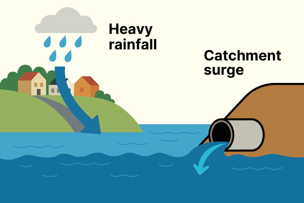
Papakura sits at the meeting point of increasing rain intensity, along with low lying areas and tide-affected drainage into the Pahurehure Inlet, and some of Auckland’s fastest urban growth—multiple pressures that compound flood risk more than in most parts of the city.
Intense Rainfall: Climate projections show 10-30% heavier downpours affecting south-east Auckland (Council’s latest Auckland-wide summary suggests roughly 10-20% more rain on very wet days, with some example storms closer to 30%)²⁵ more than northern suburbs⁴,⁵
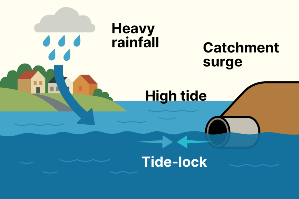
Tide-Affected Drainage: Low-lying geography and development on former wetlands, combined with stormwater systems that cannot discharge during high tides, creates a “bathtub effect” at Pahurehure Inlet outfalls.
Rapid Urban Development: The region’s highest population growth has led to increased hard surfaces that shed rainwater faster, while infrastructure struggles to keep pace.
Why floods impact Papakura area more severely: Tide locking compounds existing vulnerabilities, but flooding can occur even at low tide due to flat floodplains, modified watercourses, and infrastructure capacity limits. When these constraints combine with tide-lock, the impacts are magnified.
Tide‑lock makes flooding worse, but it isn’t the only problem. Even at low tide, flash downpours can overwhelm Papakura’s flat floodplains, modified or buried watercourses, and older/blocked pipes. When high tide and heavy rain overlap, the impacts stack up fast.
Demographic factors: High rental occupancy (42.7%) limits household capacity for resilience upgrades, while a young population (23.7% under 15, median age 32.0) affects evacuation planning and preparedness needs.⁷,¹³
Who’s Most at Risk?
Did you know? About 43% of Papakura area homes are rented, and renters are less likely to have contents insurance. Here’s what we can do: Pilot group‑buy or subsidised contents insurance for high‑risk rentals; share simple landlord maintenance checklists for flood preparedness.
Did you know? Tree canopy is ~14% in some corridors (Auckland avg ~18%), so rain runs off faster and streets heat more. Auckland’s latest climate projections show a sharp increase in hot days (25°C+) and heatwave days by mid-century²⁵, with low-canopy streets facing compounded heat and flood exposure. Here’s what we can do: Street and reserve planting with native species; rain gardens on suitable berms to slow and soak water.
Did you know? Home internet access is a few points lower than regional, and many families prefer information in languages other than English. Here’s what we can do: Use multi‑channel alerts (SMS, radio, printed flyers, Street Meets) and multilingual materials.
Did you know? Overland‑flow paths can be blocked by solid fences and walls. Here’s what we can do: Promote break‑away panels, keep swales open, and invite Council to run a “flow‑path check” in flood‑hotspot streets.
What We Learned from January 2023
On 27 January 2023, Auckland Airport recorded 265 mm over the calendar day—the city’s wettest day on record¹. Final industry loss for the January 2023 Auckland Anniversary floods reached $2.23 billion (PERILS, Feb 2024), with Treasury estimating total physical damage across the early-2023 events at $9–$14.5 billion.¹⁹
Parts of Takanini and Papakura area experienced widespread flooding and power outages, with crews unable to access damaged areas due to unsafe conditions². The event demonstrated how Papakura’s geographical position—nestled between the Pahurehure Inlet and surrounded by low-lying areas—creates flood vulnerability.
At bottlenecks like Great South Road/Slippery Creek, the road embankment acted as an unintended barrier during peak flows, with the road crest height determining how high water could rise before spilling over³. This demonstrated how infrastructure designed for different conditions now struggles with climate reality. Areas with high impervious cover and lower tree canopy (e.g., Takanini corridors) saw faster ponding—mirroring the Local Board’s adaptive-capacity hotspots.²⁰
The January floods showed that no single factor explains Papakura’s vulnerability. Tide-lock, heavy rainfall, floodplain geography, and infrastructure bottlenecks all interact, which is why planning solutions must consider the whole picture rather than one cause alone.
Why Pressures Are Intensifying
Understanding Papakura’s flood risk means recognizing that each pressure is getting worse over time. While many Auckland communities face one or two of these challenges, Papakura sits at the intersection of multiple intensifying risks.
Rainfall Is Getting More Intense
Climate change is making extreme downpours heavier. NIWA projections show that rare “1-in-100-year” rainfalls could be 10-20% more intense by late century⁴. For Papakura’s stormwater system, this means infrastructure designed for historical weather patterns will face increasingly severe tests. Areas with limited tree cover and more hard surfaces already see faster flooding—a problem that will worsen as storms intensify.
Even though total annual rainfall may fall slightly, the heaviest downpours are projected to bring significantly more rain in a short time, which is what drives flash flooding in Papakura’s flat, tide-affected catchments.
Rising Seas Block Drainage More Often
Sea levels around Auckland are rising approximately 22-33 cm by 2050, and potentially 0.58-1.11 m by 2100 (scenario-dependent), with planning allowances extending to 1.6 m by around 2130 for long-life assets⁶. In simple terms, Auckland Council’s latest summary indicates sea level could rise by up to about a metre by 2100, with Papakura’s low-lying, tide-locked outlets feeling those effects earlier because of local land subsidence. For Papakura, this doesn’t just mean coastal flooding—it means the Pahurehure Inlet’s tide-affected outfalls will be blocked more frequently and for longer periods. As sea levels rise, what are currently manageable high tides will increasingly prevent stormwater from draining, creating more frequent “bathtub effect” flooding.
For Papakura, this creates a challenging “too wet/too dry” pendulum that actually reinforces flood vulnerability. Between heavy storms, longer dry periods mean the ground and vegetation dry out more, which reduces baseflows in streams and can make soils less able to absorb the first flush of heavy rain—intensifying flash-flood risk. Drought also increases pressure on water supply, particularly affecting renters and lower-income households who have limited capacity to install rainwater tanks or buffer water costs during restrictions.
Drought: The Other Side of Climate Risk
While flooding dominates discussions of Papakura’s climate risk, Auckland Council’s latest climate summary reveals another emerging challenge: drought. Auckland currently experiences about 66 drought days per year—defined as unusually low rainfall over at least three consecutive months. Under high-intensity climate scenarios, this could nearly double to around 119 drought days per year by late century²⁵, with more frequent dry spells and drier winters and springs.
For Papakura, this creates a challenging “too wet/too dry” pendulum that actually reinforces flood vulnerability. Between heavy storms, longer dry periods mean the ground and vegetation dry out more, which reduces baseflows in streams and can make soils less able to absorb the first flush of heavy rain—intensifying flash-flood risk. Drought also increases pressure on water supply, particularly affecting renters and lower-income households who have limited capacity to install rainwater tanks or buffer water costs during restrictions.
Development Is Outpacing Infrastructure
Papakura’s explosive growth—adding over 14,000 people since 2018 within the same Papakura Local Board area boundaries⁷—is creating more hard surfaces faster than stormwater systems can adapt. New housing zones allow up to 60% impervious coverage per lot⁸, meaning every new house reduces the land’s natural ability to absorb rainfall.
Meanwhile, aging infrastructure struggles with current demands, let alone future growth. Older pipes, modified watercourses, and bottlenecks create weak points that will become more problematic as both development and rainfall intensity increase.
Growth Pressure on Infrastructure
Papakura’s population surge creates unique infrastructure stress:
- 72,318 people in 2023 Census, up 25.5% since 2018⁷
- Mixed Housing Suburban zoning allows up to 60% impervious coverage—potentially 240m² of hard surfaces on a 400m² lot⁸
Every new house covers land that can no longer absorb rainwater, while key infrastructure like the Takanini stormwater conveyance channel covers only part of Papakura area, leaving local pipes and overland paths under increasing pressure.
On top of growth, parts of Papakura area experience issues with older pipes, blocked drains, and even buried or culverted streams that no longer carry floodwater effectively. These weak points mean even moderate storms can create local flooding hot spots — a risk that intensifies when paired with tide-lock.
Addressing Multiple Risks
Given that Papakura faces multiple flood risks, effective solutions require multiple approaches:
Tide-affected drainage issues can be addressed through backflow prevention systems, regular pump maintenance, and timing drainage operations for low tide periods.
High levels of hard surfaces in residential areas can be reduced through rain garden incentives for homeowners and guidance on installing permeable driveways and surfaces.
Infrastructure bottlenecks at bridges and road crests require proactive debris clearance before severe weather alerts to prevent blockages that worsen flooding.Limited financial resilience among renters calls for multilingual emergency preparedness programs and maintenance checklists that help landlords prepare their properties for extreme weather.
What Council Is Doing
The Pahurehure Inlet Shoreline Adaptation Plan was approved by the Policy and Planning Committee on 10 October 2024, following endorsement by the Papakura and Manurewa Local Boards (with support in principle from Franklin). The plan establishes adaptive pathways—protect, then adapt, and where necessary, managed retreat—for council-owned land and assets around the inlet, including the Hays, Hingaia, Ngākōroa, Whangapōuri and Whangamaire catchments.
Auckland Council has committed substantial resources to flood resilience across the region:
- Making Space for Water: $700m+ over 10 years targeting highest-risk catchments⁹
- Water Quality Targeted Rate: $779m for stormwater improvements region-wide¹⁰
- Shoreline Adaptation: Pahurehure Inlet plan sets protect/adapt/retreat pathways¹¹
Given Papakura’s specific flood challenges, the Local Board and community continue to advocate for adequate investment to address the area’s unique risks.
Innovation in Action
These council commitments are already being implemented in Papakura through several key projects that demonstrate integrated flood management approaches—projects that balance flood reduction with environmental protection of the Manukau Harbour.
Most of Papakura’s stormwater ultimately discharges to the Manukau Harbour, which creates both an opportunity and a responsibility. Simply moving floodwater quickly downstream can reduce local flooding, but untreated runoff carries sediment, metals, and contaminants that harm harbour ecosystems. The challenge is designing systems that provide flood relief while cleaning water before it reaches the sea—exactly what Papakura’s blue-green infrastructure achieves.
The south-east Takanini growth area showcases this approach through the Artillery Drive stormwater tunnel and McLennan/Awakeri wetlands, which create a corridor that moves floodwater safely to Pahurehure Inlet while providing habitat and recreation¹². Rather than rushing water straight to the harbour, the Awakeri wetlands slow flows, allow sediment to settle, and filter pollutants through planted systems. This manages major storms more cost-effectively than traditional pipes alone, with the wetlands functioning as flood storage during heavy rainfall while treating water before discharge.²⁰

Ōpaheke Park represents another innovative approach—a 19-hectare “floodable park” that doubles as community open space and stormwater infrastructure. The park’s detention ponds and planted stream network are designed to capture heavy-rain flows and release them gradually, reducing flood risk for nearby low-lying homes including those at the base of Red Hill. Since opening in June 2025, the park provides 2 km of walking paths, a pump track, dog run, and extensive wetlands with over 50,000 new plants, demonstrating how flood management can enhance rather than compete with community amenities²⁴.
Recent decisions to pull back some Future Urban Zoned land reflect a shift toward avoiding new development in flood‑sensitive locations—local knowledge and on‑the‑ground hydrology are increasingly shaping those calls.
Equity and Renters: Targeted Support Needed
Papakura’s demographic profile creates specific flood vulnerabilities that require targeted responses. With 42.7% of dwellings rented and significant Pacific and Asian populations, many families face barriers to flood preparedness that differ from other Auckland communities.
Insurance gaps present a major challenge. Pacific peoples are about half as likely to have general insurance as other New Zealanders, while one-third of tenants lack contents insurance¹⁴. This creates particular vulnerability in low-lying areas east of Great South Road, where higher renter density coincides with faster flood ponding.
Communication barriers compound these risks. Home internet access is a few points lower than regional averages (85% versus 90% regionally), which means emergency messaging cannot rely solely on digital channels²⁰. Recent demographic shifts, including significant increases in Asian and Pacific populations, highlight the need for multilingual preparedness materials and culturally responsive emergency planning.
Financial constraints limit household resilience options. Urban South residents report lower quality of life than other Auckland areas, indicating tighter financial and social resources when floods occur²³. This affects both immediate emergency response capacity and longer-term property adaptation options.
Potential responses include targeted insurance programs for high-risk rental properties, multilingual emergency messaging through multiple channels, and landlord maintenance guidance to improve rental property flood preparedness.
Community Response and Mana Whenua Leadership
While council infrastructure and planning provide essential foundations, lasting flood resilience depends on strong community networks and indigenous knowledge systems. In Papakura, mana whenua leadership and grassroots organising are creating collaborative approaches that combine traditional water management practices with modern emergency preparedness, building the social infrastructure needed to weather increasingly severe climate impacts.
Established Responses
Ngāti Tamaoho has taken a leadership role in proposing joint iwi-community-council initiatives to protect Otaawhati (Ray Small Park) and Pahurehure Inlet. The Drury South Wetlands project incorporated tikanga Māori principles, demonstrating how traditional knowledge can inform modern flood management. Local Board chair Brent Catchpole notes: “Viewing climate change through a scientific lens is essential but so is the knowledge of people who have cared for the whenua for generations… The wetlands are both a brilliant walkway and a traditional control method, one that has been tested over centuries.” (Auckland Council, 2024c).
The Community Resilience Network Papakura (CRN) has become established as an active organization focused on education and preparation for severe flooding events, building community capacity for emergency response. The Local Board’s “Getting Climate Ready” programme is establishing Community Emergency Hubs and expanding Street Meets so residents know where to go and how to help during extreme weather events.
Current Community Initiatives
Several community-led initiatives are gaining momentum across Papakura area:
- Neighbourhood resilience building through CRN “Street Meets” and Community Emergency Hubs¹⁶
- Rain garden installation programs with council technical support¹⁷
- Stream monitoring projects led by local schools
- Business continuity planning for small enterprises¹⁸
- Integration of cultural approaches to water management from mana whenua
What Residents Can Do Now
While large-scale projects progress, Papakura area residents can take immediate action to protect their families:
Emergency Preparedness
- Know evacuation routes and have a grab bag ready
- Maintain 72-hour emergency supplies (water, food, torch, battery radio)
- Develop family emergency plans with meeting points
- Use council hazard maps to understand property-specific flood risk
- Know the nearest Community Emergency Hub and routes to reach it²²
- Keep a radio and printed evacuation information (translated where needed)²²
- Plan school pick-up arrangements during red warnings
Property & Home
- Clear gutters and drains regularly, especially before wet season
- Install flood barriers for vulnerable entry points
- Elevate electrical appliances above potential flood levels
- Ensure insurance covers flood damage
- Consider rain gardens or permeable surfaces (gravel driveways, rain gardens)
- Plant natives that absorb excess water and prevent erosion
- Retrofit with flood-resilient materials below expected flood levels
- Install rainwater tanks for conservation and flood mitigation
- Keep overland‑flow paths clear: Use break‑away fence panels or leave gaps where a mapped flow path crosses a boundary; don’t fill or raise ground across swales
- Choose permeable surfaces: Swap non‑porous paving for permeable pavers, gravel, or planting; add rain gardens where practical
Community
- Report flooding, blockages and drainage problems via the Council’s “Report a Problem“.
- Join neighbourhood emergency response groups
- Share knowledge with elderly neighbours or those with mobility challenges
- Support multilingual emergency information sharing
- Participate in stream clean-ups and native planting
Looking Forward: Economic Imperative and Community Innovation
The region-wide economic impacts of the January 2023 floods highlighted a stark reality for communities like Papakura: property values in flood-prone areas face potential decline, while ongoing productivity losses affect the broader economy. Climate impacts aren’t just environmental challenges—they’re economic justice issues that hit Auckland’s fastest-growing, most diverse communities hardest.
This economic reality makes Papakura’s collaborative approach to flood management not just innovative, but essential. The community’s developing response—combining council infrastructure investments, mana whenua leadership, and grassroots resilience building—represents an economic survival strategy for a community that cannot afford to absorb repeated major losses.
More extreme weather is coming — but Papakura can lead on adaptation. By combining council investment, mana whenua leadership, and community action, we can protect our homes, our whānau, and our harbour — and show other places what climate‑ready looks like.
Residents can explore localized climate projections using the Ministry for the Environment’s Climate Projections Map and assess flood risk through Auckland Council’s Flood Viewer.
Technical Recommendations for Council
The following operational improvements could enhance Papakura’s flood resilience through targeted infrastructure maintenance and management:
Overland‑flow path sweep: Proactively identify barriers to flow (solid fences/walls/berms across swales & flow paths) in Takanini, Rosehill, and Red Hill; contact owners and provide guidance on keeping flow paths clear.
Blockage blitz: Prioritise pre‑storm catchpit/grate/culvert clearing in mapped hotspots.
Works‑in‑rain protocol: Contractors must have a wet‑weather contingency (temporary bypassing, safe isolation of open pipes, stand‑down triggers for orange/red warnings).
Bottleneck fixes: CCTV lines to find diameter step‑downs and short choke sections that cause back‑flow; upsize those first (quick wins).
Tidal outlets review: Audit/maintain flapgates & non‑return valves at Pahurehure Inlet outfalls.
Map the hidden network: Capture local knowledge (retired staff/contractors) and fill as‑built gaps (pipe sizes/inverts, buried channels) into one asset map; publish simplified overland‑flow path sketches residents can help keep clear.
Footnotes
¹ NIWA (2023). Climate Summary for January 2023; RNZ (2023). What caused Auckland’s wettest day
² Vector (2023). Auckland floods — power outage updates (27–29 Jan)
³ Auckland Council (2023a). South FTN — Assessment of Flooding Effects
⁴ NIWA for Auckland Council (2018b). Auckland Region climate change projections and impacts
⁵ NIWA (2018a). High Intensity Rainfall Design System (HIRDS v4): Technical Report
⁶ Auckland GD15 (2024); NZ SeaRise (2022a, 2022b). Local sea-level rise projections for Aotearoa; Takiwā map viewer; Earth Sciences New Zealand (2025). Auckland’s Future Climate (TR2025/9). Retrieved from https://www.knowledgeauckland.org.nz/media/hvsjlrih/tr2025-09-s-aucklands-future-climate-summary-earth-sciences-nz-july-2025.pdf
⁷ Auckland Council (2024e). 2023 Census results — Papakura Local Board (summary)
⁸ Auckland Council (2016a). H4 Residential — Mixed Housing Suburban Zone
⁹ Auckland Council (2025c). Making Space for Water
¹⁰ Auckland Council (2024i). Summary of the Long-term Plan 2024–2034; Auckland Council Governing Body Minutes (2024-05-16)
¹¹ Auckland Council (2024a, 2024b, 2024f). Pahurehure Inlet Shoreline Adaptation Plan
¹² Water New Zealand (2019). Takanini — A greenfields approach to stormwater management
¹³ Auckland Council (2024h). Household income in Auckland; Auckland Council (2024e). 2023 Census results
¹⁴ Te Ara Ahunga Ora Retirement Commission (2022). New Zealand Financial Capability: Focus on Pacific Peoples; AA Insurance (2019). Uninsured tenants practising a false economy
¹⁵ Auckland Council (2024e). 2023 Census results — Papakura Local Board (summary)
¹⁶ Community Resilience Network Papakura. Street Meets
¹⁷ Auckland Council (2017). Rain Gardens Construction Guide; Auckland Council (2017). Stormwater Management Devices in the Auckland Region (GD01)
¹⁸ Auckland Council (2024). Helping business survive emergencies
¹⁹ PERILS (2024). Auckland Anniversary floods loss estimate; The Treasury (2023). Economic impact of the 2023 North Island weather events
²⁰ Auckland Council (2023). Papakura Local Board Plan 2023 (draft)
²¹ Auckland Council (2024). Pahurehure Inlet Shoreline Adaptation Plan (approved 10 Oct 2024; includes catchment list)
²² Auckland Council (2025a). Adapting to climate change — Papakura: Getting Climate Ready
²³ OurAuckland (2025). Auckland insights from the 2024 Quality of Life survey
²⁴ OurAuckland (2025). Ōpaheke Park opens in Papakura.
²⁵ Earth Sciences New Zealand (2025). Auckland’s Future Climate: Summary Report (TR2025/9). Auckland Council.
Full References
AA Insurance. (2019). Uninsured tenants practising a false economy.
Auckland Council. n.d.-a. Flood Viewer (interactive map).
Auckland Regional Council (2003). TP10: Stormwater management devices — design guideline manual.
Auckland Council. (2014a). Takanini stormwater conveyance corridor — District Plan (Papakura), Plan Change 48.
Auckland Council. (2015). Stormwater Asset Management Plan 2015–2045.
Auckland Council. (2016a). H4 Residential — Mixed Housing Suburban Zone (Operative in Part). Auckland Unitary Plan.
Auckland Council. (2017). Stormwater Management Devices in the Auckland Region (GD01), Guideline Document 2017/001, Version 1 (December 2017).
Auckland Council. 2023a. South FTN — Assessment of Flooding Effects (Te Tupu Ngātahi Supporting Growth, Oct 2023).
Auckland Council. (2023). Papakura Local Board Plan 2023. Auckland Council.
Auckland Council. (2024). Coastal climate change and sea‑level scenario guidance for land‑use planning in Auckland (GD15). Updated November 2024.
Auckland Council. (2024a). Protecting the Pahurehure Inlet and Manukau Harbour East coastlines. OurAuckland.
Auckland Council. (2024b). Pahurehure plan says assets can be managed. OurAuckland.
Auckland Council. (2024c). Sacred sites will face climate impacts. OurAuckland.
Auckland Council. (2024d). Te Tāruke-ā-Tāwhiri: Auckland’s Climate Plan — Progress Snapshot 2024.
Auckland Council. (2024e). 2023 Census results — Papakura Local Board (summary).
Auckland Council. (2024f). Policy and Planning Committee — 10 October 2024 (agenda & SAP).
Auckland Council. (2024g). Long-Term Plan 2024–2034 (summary hub).
Auckland Council. (2024h). Household income in Auckland.
Auckland Council (2024i). Summary of the Long-term Plan 2024–2034 — Built environment.
Auckland Council. (2024). Pahurehure Inlet Shoreline Adaptation Plan (web overview). Auckland Council. (Approved 10 Oct 2024; includes catchment list.)
Auckland Council. (2025a). Adapting to climate change — Papakura: Getting Climate Ready.
Auckland Council. (2025b). Property risk categories (buy-out information).
Auckland Council. (2025c). Making Space for Water.
Auckland Council Governing Body Minutes (2024, May 16). (confirms $779 m WQTR programme funding)
Earth Sciences New Zealand. (2025). Auckland’s Future Climate: Summary Report. Prepared for Auckland Council. Technical Report TR2025/9, July 2025. https://www.knowledgeauckland.org.nz/media/hvsjlrih/tr2025-09-s-aucklands-future-climate-summary-earth-sciences-nz-july-2025.pdf
Cain, T., Prakash, A., & Ipsos. (2025). Quality of Life Survey 2024: Tāmaki Makaurau / Auckland Report. Auckland Council TR2025/3.
Community Resilience Network Papakura. crnpapakura.com
Commission for Financial Capability (CFFC). (2019). Low insurance among Māori.
ICNZ. (2024). Cost of natural disasters (industry data).
IPCC. (2021a). Climate Change 2021: The Physical Science Basis. Contribution of Working Group I to the Sixth Assessment Report of the Intergovernmental Panel on Climate Change. Cambridge University Press.
IPCC (2021b). AR6 WG1 Summary for Policymakers, A.1.7 (sea-level rates).
LAWA. (2024). Papakura stream — flow monitoring site.
MfE (2018). Climate Change Projections for New Zealand (2nd ed.).
Ministry for the Environment. (2024a). New Zealand Climate Projections Dataset — Climate Projections Data.
Ministry for the Environment. (2024b). Climate projections map.
New Zealand Gazette. 2017. Land Taken for Stormwater Purposes—Takanini Stormwater Conveyance Corridor, 121 Grove Road, Papakura (Notice 2017-ln58). NIWA. (2018a). High Intensity Rainfall Design System (HIRDS v4): Technical Report.

0 Comments